
 200.jpg)

 6
6The North Fork lahars
The most devastating product of a volcanic eruption is a lahar, from an Indonesian word for mudflow. Technically, these are actually debris flows and contain relatively little mud, but they are still often referred to as mudflows.
Why do they occur? During an eruption much of the snow and ice on the volcano peak may melt to produce a sediment-laden slurry that moves rapidly downhill, weeping away everything in its path or, at the distal end, burying everything in an abrasive mixture of silt, sand, and gravel.
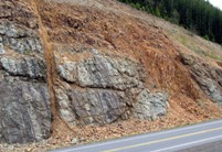
Non-eruptive lahars also occur, initiated by landslides or by rain events. The rock mass making up a volcano is surprisingly weak because of cooling-induced fractures and because of hydrothermal alteration (Fig. 1) , so collapse of a large segment of the volcano, with no warning from rising magma, can occur and generate damaging lahars.
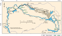
The May 18, 1980 eruption of Mount St Helens produced lahars of several types in most of the drainages surrounding the mountain. In the South Fork of the Toutle River, the first lahar arrived at Gardner Park at about 1015, an hour and a half after the eruption (see map, fig. 2). The North Fork drainage remained quiet, but the mountain was gathering its strength for the most destructive event of the day.
The giant landslide that initiated the eruption had left a pile of rubble referred to as the debris avalanche deposits. During the morning, this debris pile accumulated water from the now-blocked Toutle River, adding to water it contained from melting snow (about 25 %) and from groundwater in the rocks inside the mountain (about 75 %).
Once enough water had percolated to the front of the debris pile - 35 to 50 % by volume - about 0.1 to 0.2 km3 of debris transformed into a flow and traveled down the North Fork of the Toutle at speeds ranging from 2 to 10 m/sec. Flow was fastest in narrow stretches of the valley such as at Tower Bridge.
The North Fork lahar was much larger than those in the other drainages, but travelled more slowly (fig. 5). The flow reached Tower Bridge at about 2030 hours, 12 hours after the eruption and quickly swept the bridge off its foundation. The flow continued downstream into the Cowlitz River, filling it, and then moved into the Columbia at about 0400 hours the next day, where it raised the river bed above the miniumum ship channel depth, trapping ocean-going vessels in Portland (see Downstream Lahars).
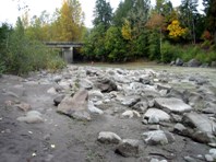
The Toutle still carries a very heavy load of suspended sediment. To minimize the downstream impact of siltation on the ports of Kelso and Longview and to lower flood risk on the Cowlitz River, the US Army Corps of Engineers built a large sediment retention structure on the North Fork (fig. 6).