


The South Fork lahars -- Gardner Park
The most devastating product of a volcanic eruption is a lahar, from an Indonesian word for mudflow. Technically, these are actually debris flows and contain relatively little mud, but they are still often referred to as mudflows.
Why do they occur? During an eruption much of the snow and ice on the volcano peak may melt to produce a sediment-laden slurry that moves rapidly downhill, sweeping away everything in its path or, at the distal end, burying everything in an abrasive mixture of silt, sand, and gravel.
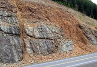
Non-eruptive lahars also occur, initiated by landslides or by rain events. The rock mass making up a volcano is surprisingly weak because of cooling-induced fractures and because of hydrothermal alteration (Fig. 1) , so collapse of a large segment of the volcano, with no warning from rising magma, can occur and generate damaging lahars.
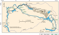
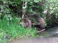
The May 18, 1980 eruption of Mount St Helens produced lahars of several types in most of the drainages surrounding the mountain. In the South Fork of the Toutle River, the first lahar arrived at Gardner Park at about 10:15, an hour and a half after the eruption. It was made up largely of rock fragments in a sandy matrix. In the afternoon, other lahars arrived that contained mostly pumice in the clasts (see lahar map -- Fig. 2) The force of these flows was enough to move trains from their tracks and to transport railroad wheels as clasts (Fig. 3)
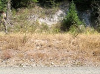
The stratigraphy of the deposits can be seen along the gravel road leading into Gardner Park. (Fig. 4). A walk across the gravel bordering the stream will also reveal many lahar features, although these deposits have been reworked by subsequent floods and will eventually become unrecognizable as lahars as fragile lithologies fall victims to weathering (Fig.5). At some point it will become difficult to persuade newcomers that such a tranquil spot can pose such severe danger (Fig.6).
Grain-size distribution in the lahars (Fig. 7) shows very little clay, but that silt + clay is about 10 %. Deposits with > 5 % fines like these are referred to as "Cohesive lahars" (Scott et al. 2001). However measurements of Atterberg limits in our lab have shown the lahar deposits generally to be non-plastic, reflecting the low clay content. The median grain size is in the gravel range, in contrast to alluvial deposits which are all sand. Thus these lahara carry much larger clasts than a stream with the same flow.

Figure 7. Grading of St Helens lahars