
The Canal in Clifton

Feeder Basins
To keep a constant water level in the canal, a series of feeder ponds or "basins" were needed. Two were constructed at the foot of Clifton Avenue along the northern edge of the Clifton neighborhood. The eastern pond was referred to as the Blair Basin, while the smaller pond to the west was known as Mummert's. It was subsequently split by the relocation of Clifton Ave in the 1920s.
[click here for larger version]
The map above is from "Playmates of the Towpath" by Charles Ludwig, 1929.
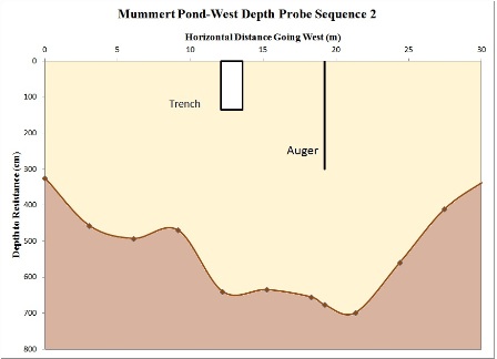
Depth profile of the western portion of the remnants of Mummert's pond. Sampling appeared to go into glacial lake bed clays at about 200 cm, so the remaining 500 cm of soft material is likely lake clay.
On the 1869 map of Clifton, the Blair Basin is referred to as the "S. Blair Fee Pond." It remains largely intact, although as a wetland. The feeder channel connecting the pond to the canal is still visible (see below). Just to the east of Blair Pond, the canal crossed the Mitchell Ave aqueduct, originally a wooden structure, which failed catastrophically in the 1880s, perhaps owing to soft Pleistocene lake bed clays in its foundations.
