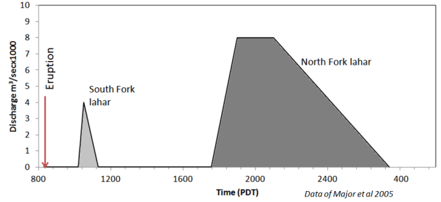
Lahar movement
The lahars in the South Fork of the Toutle were small but fast moving. The large lahar in the North Fork, however, was much larger and lasted much longer, a consequence of having a secondary origin from the debris avalanche.
Arrival time of lahar peak discharge |
|||||||
| Time of | Speed | ||||||
| South Fork | Miles | Peak stage | ft/sec | ||||
| Eruption at source of South Fork | 69.4 | 832 | |||||
| David Crockett's car | 63.5 | 850 | 27.4 | ||||
| Weyerhaeuser Camp 12 | 42.4 | 1010 | 23.5 | ||||
| Highway 504 (Coal Banks) Bridge | 36.8 | 1050 | 12.3 | ||||
| Tower Bridge | 26.5 | 1150 | 15.1 | ||||
| Castle Rock Bridge (gage) | 17.3 | 1330 | 8.1 | ||||
| Longview Water Treatment Plant | 5.2 | 1700 | 5.1 | ||||
| North Fork | |||||||
| Eruption (dam below Spirit Lake) | 74 | 832 | |||||
| Elk Rock area | 63 | 1330 | 7.8 | ||||
| Weyerhaeuser Camp Baker | 55 | 1500 | 6.9 | ||||
| Toutle Boys Ranch | 40.2 | 1800 | 7.9 | ||||
| Toutle River gage (1/4 mile below 504 Br) | 36.4 | 1900 | 5.6 | ||||
| Tower Bridge | 26.5 | 2115 | 6.5 | ||||
| Castle Rock Bridge (gage) | 17.3 | 2400 | 4.9 | ||||
| Longview Water Treatment Plant | 5.2 | 400 | 4.4 | ||||
| Source: Cummans 1983 table 2 | |||||||